Why an Overlay Zone for Route 3?
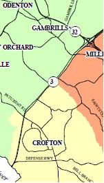
Fig. 1: Route 3 is currently divided into three small area planning districts, Millersville (orange), Odenton (green), and Crofton (yellow)
An ōoverlay zoneö has been proposed for the Route 3 corridor to enhance the highway features and improve coordination and functionality to everyone's benefit. One of the challenges faced by Route 3 is that fact that the highway is split into 3 different small area plans. Anyone attempting to understand the highway future and what should developers expect when considering Route 3 is a difficult challenge. Furthermore, the 3-way ōsplitö serves to fragment the highway, furthering the uncoordinated strip appearance.
Many other jurisdictions have established highway overlay zones to improve planning serve as a coordination point for such things as sign pattern enhancement, pedestrian walkways, landscaping patterns, traffic, defined environmental resources, and public park enhancements. An ōoverlay zoneö as proposed is not meant to replace or change the important ōSmall Area Plansö, just an additional zone that would overlay onto the existing process. This zone would be expected to be defined and developed through an citizen panel representing interested stakeholders (similar to the Round-table concept implemented by Art & David).
With this additional mechanism in place, discussions and future planning for the highway will be enhanced, and prevent decline of the highway into the stereotypical problems that occur with uncoordinated highway strip development (ie. Rt 1 & Rt 2). The county's General Development Plan (GDP) process is an excellent starting point for establishing an overlay zone, as long-range planning is an immediate topic for our county decision-makers, when changes can be more easily implemented. Discussion on this topic is encouraged, and support is needed on a broad basis for this to happen. Please consider the future of Route 3!